
This article was written in collaboration with TERRE VERTE.
About This Article
This is Article 1 in a series on the Sahelian bocage. It introduces the bocage as a field-tested operational method for landscape regeneration in the Sahel. Developed and refined by Terre Verte through long-term work at the Guiè pilot farm and subsequent sites, the method integrates land organization, water control, vegetation structure, and production systems into a single applied framework.
The focus here is strictly on the method itself: how it is designed, how it functions in practice, and why it delivers consistent results under Sahelian conditions. Rather than advancing a general theory of dryland restoration, the article examines the bocage as an engineered response to erosion, runoff, vegetation loss, and agricultural instability observed across the region.
Grounded in field evidence from Burkina Faso, the article positions the Sahelian bocage as operational infrastructure for regeneration and establishes the technical basis for examining its landscape-scale implications in the articles that follow.
Problem Context
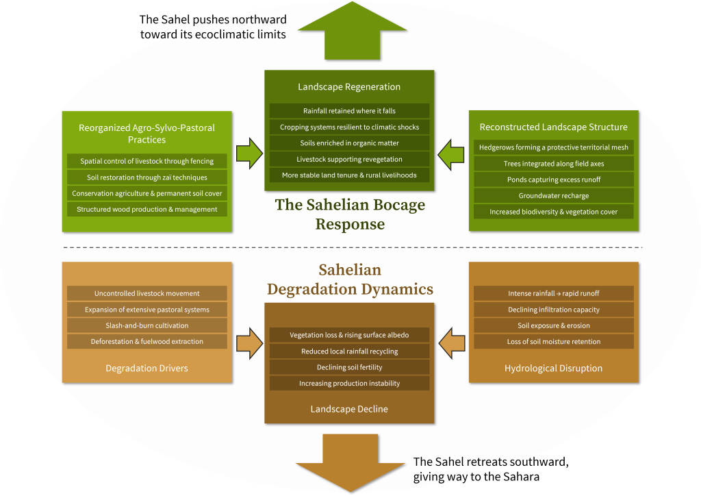
Across much of the Sahel, land degradation follows a repeatable pattern shaped by climate variability and cumulative land-use pressure. Rainfall arrives in short, high-intensity events; most is lost as runoff rather than retained in soils. Vegetation cover thins, infiltration declines, and exposed soils erode under wind and water.
Extensive agro-sylvo-pastoral systems have historically adapted to variability, but rising demographic pressure, shortened fallows, uncontrolled grazing, wood extraction, and recurrent fire have weakened their stabilizing functions. The result is a landscape increasingly defined by hydrological loss, declining soil fertility, and production volatility.
Conventional responses have often addressed symptoms in isolation – tree planting without water control, soil works without grazing management, or plot-level improvements without territorial coordination. Under Sahelian conditions, these partial measures rarely persist. The problem is not the absence of techniques, but the absence of an integrated field method capable of reorganizing land, water, vegetation, and use into a coherent and durable system.
The dynamics of degradation and regeneration can be understood as two opposing landscape trajectories.
.
.
The Method
The Sahelian bocage is a spatially organized land-use system designed to retain rainwater, stabilize soils, protect vegetation, and enable reliable agro-sylvo-pastoral production under Sahelian conditions. Developed through long-term field practice by Terre Verte, the method combines land consolidation, hydrological control, vegetative structuring, and collective management into a single operational framework.
At its core is the bocage perimeter (wégoubri): a defined rural area organized into individual plots and shared commons under customary co-ownership. Each plot is structured to slow runoff, capture water, and support vegetation through a coordinated system of earthen bunds, shrub hedges, infiltration points, and controlled access. Commons – including firebreaks, perimeter fencing, access routes, ponds, and shared production zones – provide the structural continuity that makes parcel-level improvements durable at scale.
The method operates as a designed mesh rather than a collection of isolated techniques. Hedgerows regulate livestock movement and wind exposure; bunds and ponds regulate water; field orientation adapts to slope; and hedgerow reforestation is integrated to support cultivation without constraining mechanization. Together, these elements produce a “zero-runoff” landscape logic in which rainfall is retained where it falls and progressively reintegrated into soil and biomass systems.
Operational Mechanics
Implementation begins with site diagnosis and layout design. Technicians assess slope, runoff pathways, soils, and existing land use, then define the perimeter, commons, circulation routes, and plot structure before physical works begin.
Execution proceeds in a structured sequence. Surveying and clearing establish alignments; earthworks form bunds, ponds, and access paths; fencing and hedgerows secure the perimeter and regulate livestock movement; and plot infrastructure is completed with infiltration points, tree lines, and field orientation adapted to terrain. Works are typically carried out through high-intensity paid labour (HIMO), combining precision execution with local capacity-building.
Establishment and operation follow completion. Farmers adopt crop rotations, soil restoration practices such as zaï, and controlled grazing systems supported by seasonal electric fencing. Commons are maintained collectively under customary landholding groups, ensuring upkeep of hedges, firebreaks, and shared infrastructure while enforcing rules on livestock, fire, and wood harvesting.
Field Evidence From Burkina Faso
Long-term implementation across multiple sites in Burkina Faso demonstrates the operational reliability of the method under variable Sahelian conditions. Since the 1990s, bocage perimeters developed through Terre Verte and its partners have shown consistent improvements in water retention, vegetation recovery, and production stability across diverse local contexts.
Field results indicate sustained yield gains following soil restoration. In experimental plots within the Guiè/Tankouri perimeter, average sorghum yields of about 2,200 kg/ha were recorded over an 18-year period (2006–2023) with mean rainfall around 736 mm, representing roughly twice the standard regional averages.
These outcomes reflect cumulative hydrological recovery rather than short-term input effects.
Implementation has expanded incrementally through pilot-based dissemination. To date, more than 2,100 hectares have been developed across multiple provinces, benefiting hundreds of farming households while enabling continued technical refinement under real operating conditions.
Replicability Conditions
The Sahelian bocage is replicable under defined conditions. Its performance depends less on isolated techniques than on whether biophysical suitability, labour organization, and institutional arrangements are aligned from the outset, as demonstrated across multiple sites implemented by Terre Verte.
- Biophysical prerequisites – Degraded or erosion-prone dryland landscapes with sufficient rainfall variability to benefit from retention systems; soils capable of structural recovery under controlled runoff and vegetative coverLabour and organizational requirements – Availability of trained technicians, coordinated local labour for earthworks and planting (often via HIMO), and functioning landholding groups to manage commons
- Institutional continuity – Local governance capable of enforcing livestock control, fire management, and wood harvesting rules over time
- Time horizon and cost profile – Multi-season establishment period with front-loaded labour investment and progressive productivity gains rather than immediate returns
These conditions define the operational envelope within which the method can be transferred reliably across Sahelian territories.
Conclusion
The Sahelian bocage demonstrates that durable regeneration in dryland environments depends on physical reorganization of land and water rather than isolated technical fixes. By integrating hydrological control, vegetative structure, land-use planning, and collective management into a single operational system, the method converts degraded terrain into stable and productive agro-sylvo-pastoral landscapes.
Under Sahelian conditions, this approach functions as infrastructure rather than intervention. Its scaling logic lies in replication of the perimeter model across contiguous territories, where coordinated implementation progressively restores hydrological balance, soil function, and production reliability at landscape scale.
This is Article 1 in a series on the Sahelian bocage. The next article, Landscape Transformation, examines how the method restructures vegetation, production systems, and settlement patterns at landscape scale.
Featured image credit: Terre Verte, Burkina Faso – www.eauterreverdure.org
